As snow falls across Colorado, Habistack weather forecasting API gives drivers crucial information
November 17, 2022 by Rich Kurtzman, Brand Communications @ Fathym
In this piece
- Habistack weather forecasting API uses AI and machine learning to give accurate forecasts
- Colorado snowstorm gives a chance to show point and route-based forecasts
While it’s been a warm and mostly dry fall so far in Colorado, the front range is getting hit hard by a strong snowstorm this morning.
With one week until Thanksgiving, it’s later than in other years for the first “real” snow for the year. But either way, the storm is here and promises to bring up to 10” of snow to central and northern parts of the state. Most of the heaviest snow will fall during the evening commute and overnight, making tomorrow morning’s commute in Denver, Boulder and Fort Collins likely slower and slipperier than normal.
Using Fathym’s Habistack weather forecasting API, we are looking forward to this fall and winter to monitor major weather events in the Rocky Mountains and across the United States.
Habistack is a robust, feature-rich API that offers a powerful suite of weather forecasting and open-source data visualization tools.
Habistack combines the world's best weather forecasts with statistics-based, machine-learning techniques to tackle the largest datasets, including road weather. Habistack offers developers comprehensive weather forecasting capabilities over freely chosen locations and routes across the globe. The API delivers a unique suite of highly specialized forecast variables derived through statistically based machine learning models.

It uses 15 data measurements and then evaluates them using artificial intelligence and machine learning.

Habistack is open and free to the public to use. There are also pricing plans for developers and companies that want to use Habistack APIs to forecast weather and road conditions in their own applications.
Road Weather
Using that deluge of data, then piping it into our forecast engine using artificial intelligence and machine learning, Habistack allows users to see not only point-forecasts, but route-based forecasts, too.
Within the Habistack app, there's an area where you can try out the APIs by entering start and end cities to get road-based forecasts.
Let’s see how that works, and all the different data sets a driver can have at their fingertips.
Understanding the lay of the land | The Front Range
For those not from around here, let’s give a quick introduction to how Colorado’s and Wyoming’s topography creates weather.
The Rocky Mountains run from western Canada all the way down into New Mexico, 3,000 miles in total.
In Colorado and southern Wyoming, the front range runs from Cheyenne down to Pueblo, CO. What it refers to is where the Rocky Mountains end and the plains begin. Which is where native Americans originally settled the land, and then the Spanish came in the 16th century and then in the 19th century Denver City was founded by General William Larimer.
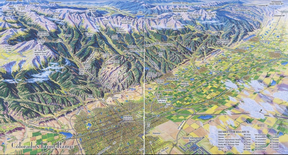
This travel brochure from Boulder, CO shows visually how the front range looks, nestled up, east of the Rocky Mountains.
Why did folks settle on the front range and why are cities blowing up in population across the area? Originally there was a gold rush, as gold and other minerals washed down from the mountains in the rivers. Besides that, it’s relatively flat land, the snowmelt from the mountains provides plenty of drinking water, and those mountains can sometimes shield the front range from massive storms.
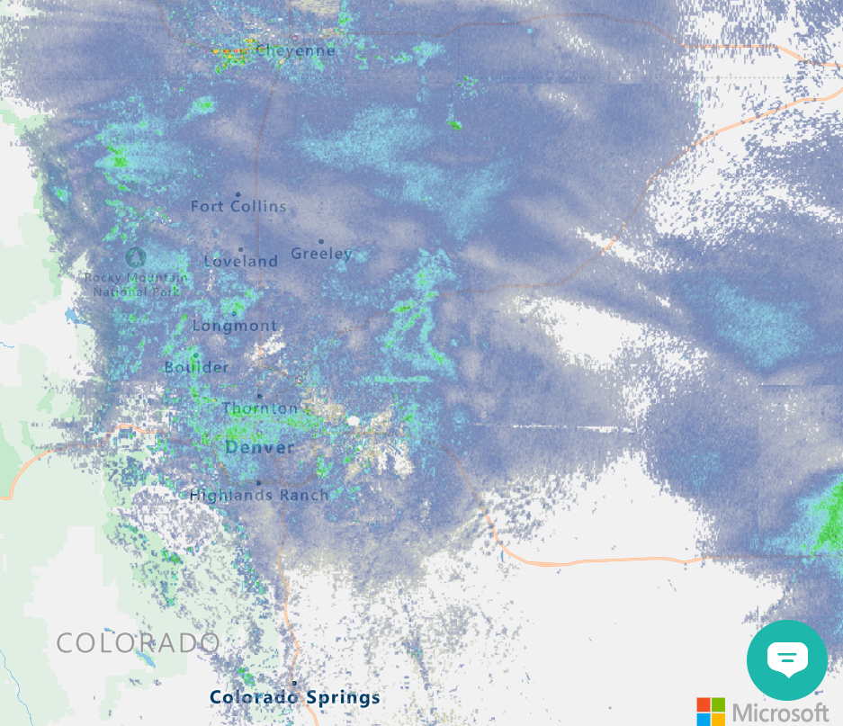
Other times, the front range almost “traps” storms as they move through. That’s what we’re seeing today, where snow is falling hard on the front range and not so much in the mountains west of population centers.

A picture of the storm using Habistack’s radar reflectivity from Colorado Springs north to Cheyenne, WY. Taken on 11.17.2022 at 12:04 p.m. MDT
Use Case | Denver to Cheyenne, WY in a snowstorm
If you’re driving anywhere today in Denver, Boulder or Fort Collins, the roads may be a bit treacherous today for your evening commute. And as the heavier snow falls this evening, it will likely make tomorrow’s Friday morning commute a hassle, too.
For this use case, we’ll show how Habistack’s API works within apps and can show road state (icy, snow, wet), delay risk and more.
First, picking the right route is key. The 100-mile journey can be completed by taking more than one route, and each has their own, unique travel times as well as weather and road conditions.
Here are a look at the three different routes:
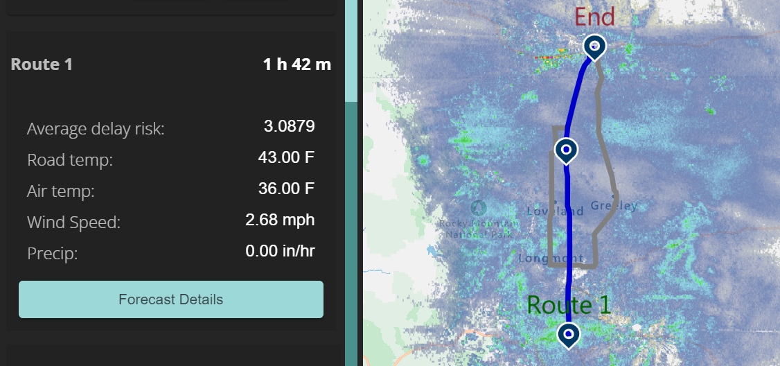
Via I-25
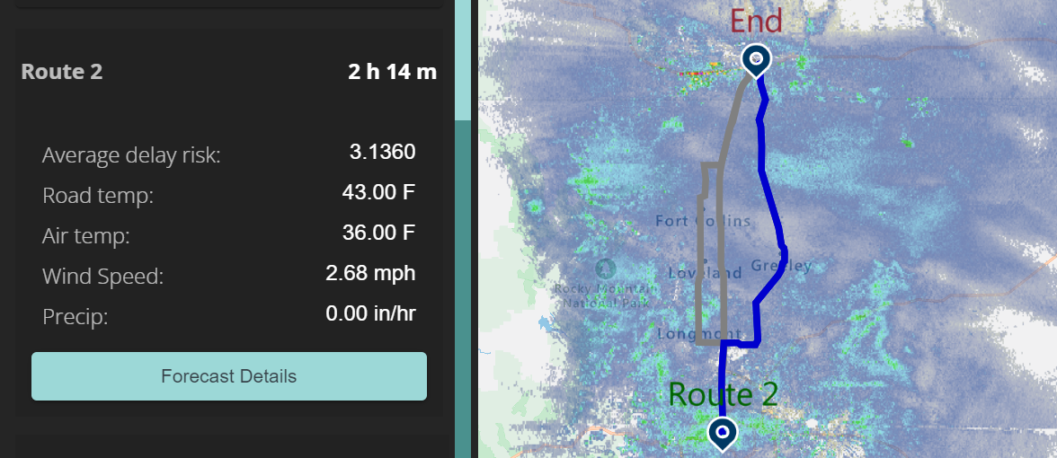
Via I-76
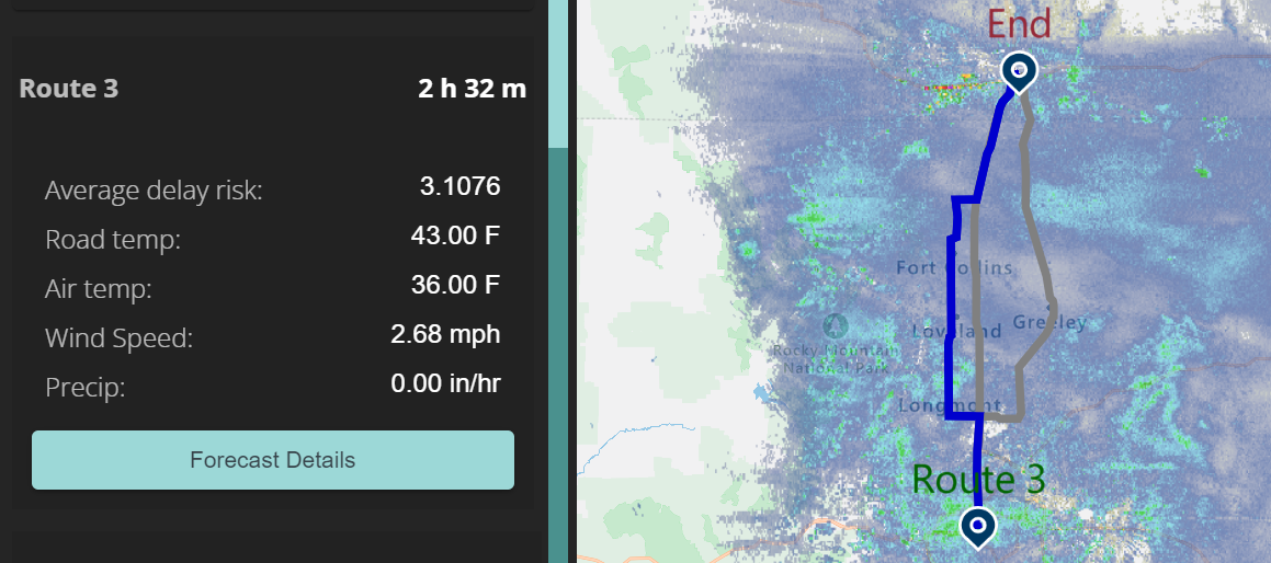
Via Highway 287
Now, what you see from the route previews is Route 1 is much faster than the others, 1:42 vs. 2:14 or 2:32 minutes. It’s also important to keep in mind that most direct route is 1-25, so it will likely be busier than other routes in terms of traffic, but will also be plowed more often than others.
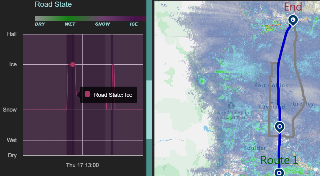
Road State
The road state tells drivers if the road is dry, wet, snowy or icy. As you can see on the left side, there is snow all along the route, and north of Denver (see corresponding point on the map) there will be ice, as well as near the state line. And as you use Habistack, hovering the mouse over the lefthand graph will create corresponding data points in the map, letting users know exactly where to expect adverse conditions.
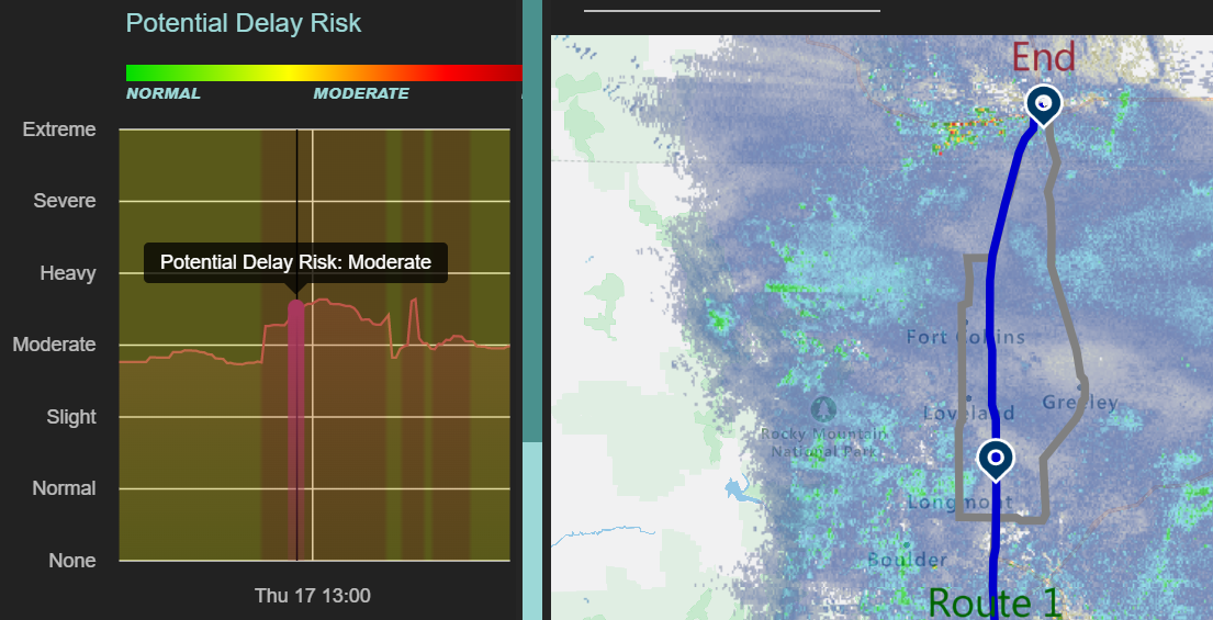
Delay Risk
The potential delay risk notes where a driver may be slowed down, extending the usual time to go from Point A to Point B. The entire route is at least a “slight” delay risk, while it ramps up into the “moderate” category starting where that icy road begins, north of Denver.
It’s great to know ahead of time where you may be slowed down, and also where you may need to slow yourself down to drive safely on icy roads.
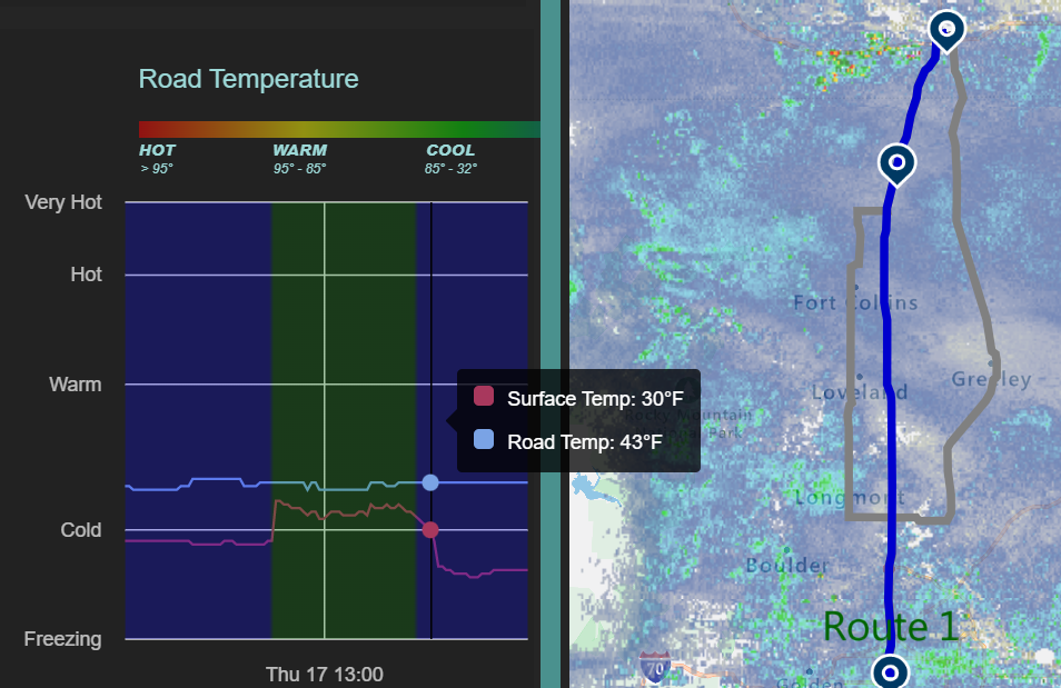
Surface/Road Temperature
Also of note is the surface and road temperatures. Later in the drive, as the sun sets, the surface temperature plummets below freezing. Luckily, road temperatures remain above freezing at the shown time in the day, otherwise they could quickly freeze over and become extremely dangerous.
Conclusion
Driving on wet, snowy and icy pavement at highway speeds can get tricky. By using Habistack and creating apps, your travels can be safer, easier and less stressful as you prepare for what’s in your future.
Habistack can help individuals, teams and even companies travel the country with safety and ease thanks to pin-point and route-based forecasts. Try today at Fathym.com.
Habistack is also mobile-friendly and allows folks stuck in traffic to search for alternate routes and/or preview weather which will impact their drive.